In this special edition of Clause 101 we track the latest news and developments in the field of e-Planning.*
Amendment Process Streamlined through Wikis
The government has responded to criticism of prolonged planning scheme amendment processes by shifting management of the VPPs and planning schemes to a new website, Wikischemia.
The new system builds on the proposal under Modernising Victoria’s Planning Act to allow amendment proponents to undertake steps in the amendment process. The new process will follow this initiative to its logical conclusion by placing the VPPs and all planning schemes on an online wiki, where users can edit content at will.
“This is an exciting leap into the 21st Century,” said Planning Minister Justin Madden. “It makes the planning system more democratic, responsive, and flexible. If there are new policy challenges, schemes can be updated in minutes. Mistakes and problematic provisions won’t sit in schemes for years without being fixed. Best of all, our tests show a substantial improvement in amendment processing timeframes, with the average length of the amendment process slashed from 20 months to 0.1 seconds, assuming you have broadband.”
The Minister dismissed concerns that constantly changing schemes would create uncertainty in the community. “On the contrary, this will increase certainty. Any particular user of the system can be certain that the scheme can meet their needs at any given time.”
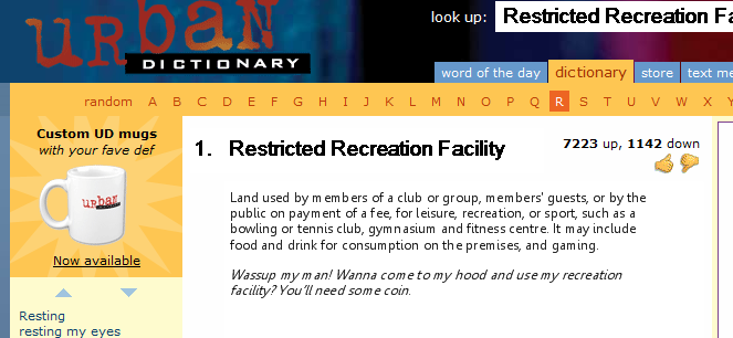
Not all of the VPPs have been shifted to Wikischemia. Land Use Terms will now be hosted at UrbanDictionary.Com (pictured), while amendment updates will now be posted on the DPCD twitter account, @VPPUpdates.
“140 char lmt 4 VPP updtes wll ld 2 bst cmmniction eva,” said the Planning Minister.
Planners Slam “Intrusive” Street View Images of Lazy Planners
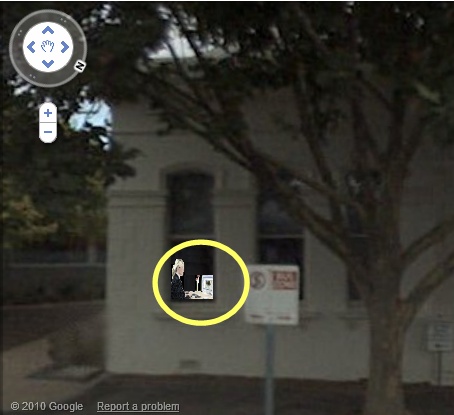
A fresh privacy storm has arisen surrounding the controversial Google Street View application after images from the service showed Council planners using it to do their site inspections.
 Google have attempted to allay privacy concerns by keeping Street View resolutions low, blurring faces and number plates, and only photographing public places. Despite these measures, Street View images have nevertheless captured intrusive images of planners failing to visit sites for which they were processing planning applications (right).
One of the pictured planners has defended her reliance on virtual tools. “Increasingly, our experience of public space will be a virtual one,” she said. “People are spending less time outdoors, and more time in virtual environments. If you carry current trends forward, you see the trend line for proportion of time spent outdoors reach zero in about 2018. At that point, the appearance of buildings in Street View will actually be more important than the appearance in the so-called ‘real world.’”
Devices such as the iPad epitomised this shift. “It’s when you have a touch-screen, GPS –enabled device like the iPad that you really unlock the potential of Street View,” she said. “The GPS fixes it on your current location; the touch screen allows intuitive manipulation of the virtual world. This allows a truly compelling and immersive simulation of the experience of standing in your current location.”
Councils should update practices to account for the new technology, she argued. “For example, in assessing sight lines, many Councils assume a stationary view point 1.7m above ground level. Going forward, the critical viewing position will be from a multi-directional camera mounted on a pole above a speeding hatchback.”
Google to Launch Innovative Web Services for Planners
On-line giant Google has entered the planning portal business, announcing two new services for planners.
Google Planner, launching late 2010, will include comprehensive property information reports that for any address will instantly generate title details, planning controls, aerial photographs, and infrastructure and drainage information. It will be followed in mid 2011 by Google Applicant, which at the push of the button will generate a design and supportive planning report for a six dwelling medium density development.
A complementary service, Google Neighbour, will allow concerned residents adjacent to properties for which a Google Applicant proposal has been lodged to search for available rental properties at an appropriate separation from the site.
Some resistance remains, however. “Google has no place at the Tribunal,” VCAT said in a statement. “Anyone who has tried to find a decision using the austlii search engine knows that.”
Originally published as a Clause 101 item in Planning News 36, No. 7 (August 2010).
* Note: from December 2010, e-planning will be rebranded as iPlanning.
